Posts

Showing posts with the label Otautau Area History

Southland Farmers Co-Op Association Ltd.

Image
This building is situated on the corners of Main & Alderly Sts, Ōtautau (currently Farmlands). Recently I was priviledged to do some research on this site and building for a reunion. Below is a vastly abridged version of this: In 1878 the blocks of land the Co-op was built on in 1907, were given in a Govt. Crown Grant, to Frederick Augustus Price, on 28 June 1873, for the price of £6/10 & £5/5: Frederick was a son of Thomas & Julianna Price who built and owned the original Ōtautau Hotel, next door. This was not long after the initial survey of the town in 1872. BELOW: 2007.2.3.30 – from Museum Collection. New Farmer’s Co-op store, dated to 1912 – 1913, based on other businesses seen in photo. In 1984, a Southland Times article stated "Company Spends $100,000 on renovations” and lists dates, names and other information. This is interspersed here with other recorded fact: - The Ōtautau branch, opened in 13 Sept 1907. The first store manager was Mr George. - Del...

MARY DONNAN - one of Ōtautau's extraordinary personalities:

Image
Born 1st Sept 1886 at High Mark, Wigtownshire, Scotland, Mary Robson Donnan was the only child of Martha Biggart (nee Hogarth) and William Donnan. Although her parents had married in Glasgow, William went out to Australia, before going on to New Zealand, where Martha and Mary joined him. The family eventually came to Ōtautau, moving there in 1897 when Mary was still a child, living at Woodside Farm, shown below: ‘Woodside’ Ōtautau NZ, 1919. From Ōtautau Museum “Miss Shaw” Collection #2007.2.3.54 (Photographer, Mary Donnan) PHOTO – IN PUBLIC DOMAIN From here, Mary attended Ōtautau School, and it was there she met with Ina Shaw; they grew up as best friends and went on to share a lot of their lives together, even moving together when their respective parents died. After leaving school, then going to Otago Girls High School, also doing teachers training at Dunedin Training College, Miss Donnan was the “infant class” school teacher at Ōtautau School from 1908 - for over 30 years! ...

Otautau Early Days:

Image
The Land, Buildings, Surveys & Township - There have been claims made in some publications, that Otautau was founded and grew during the 1860's, in response to the Central Otago Gold Rush. During the last four years of in-depth research, I have found nothing at all to substantiate these claims, which appear to have originated in a book on the Western Southland area, been repeated in a book which touches on early Otautau history, then copied again and cited in a paper on Otautau in more modern times. However, there are no original citations or sources for this information, and no early sources were found anywhere, that verified it. While ‘The Otautau’ as it was known, definitely had its first building by 1862 – namely the Otautau Accommodation House (built on the 10acre block where the Flour Mill and later Crown Hotel were situated), it was not until 1872 that the township was surveyed. Interestingly, the original survey map shows only the Otautau Accommodation House, it...
Image
Land & Family history information from Otautau District: EARLY LANDOWNERS 1. William and Agnes Johnston farmed one of the largest sheep runs in the Otautau District - Wrey's Bush run 153 (approx. 30,000 acres), around 1869. They purchased the freehold land (around 10,000 acres) and signed up for the rest of the leasehold land (another 20,000 acres) and then named this run "Annandale", after the valley of the Annan, south of Moffat, where William and Agnes had lived in their early days in Scotland. In 1871, the records show that Annandale ran 10,500 sheep and that in 1875 this had increased to 15,000 sheep. The boundaries of this huge Annandale block were: on the north - the boundary between Wairio and Wairaki (an extension of Crampton Rd); on the west, run 143 (Birchwood Estate) and run 133 (Waicola Estate), including the Wairio stream in the north as part of that boundary; to the south - more or less a straight line from Wairio Hill to the Allenby ...

The Horner boys - 100 Years of WW1 Commemoration:

Image
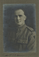
Rifleman Tui George Groves E Horner #42667 – NZRB: and Clifford Charles Horner #74579 – Mounted Rifles: These two first cousins were both in WW1. Their family was originally from Papanui, Christchurch, but they moved here to take up land in Heddon Bush before the onset of the war, which was on the Oreti Plains. Both the boys had this as their address on enlisting, and both were farming at the time. Tui who was called ‘Tim’, was born in 1894 in Christchurch. His parents were George Groves and Eliza (nee Bishop) Horner of Heddon Bush. On enlisting, Tim left NZ on 26/4/1917 bound for Plymouth, Devon, England, on board the ‘Pakeha’. He signed up as a Rifleman with NZRB, J Company Reinforcements. He looks rather dashing in his uniform, below!                                        ...